


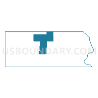
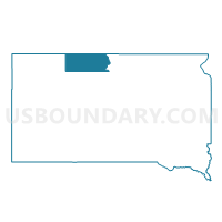
VTD-precinct Archambault, Corson County, South Dakota
About
Outline

Summary
| Unique Area Identifier | 667182 |
| Name | VTD-precinct Archambault |
| County | Corson County |
| State | South Dakota |
| Area (square miles) | 197.07 |
| Land Area (square miles) | 196.32 |
| Water Area (square miles) | 0.75 |
| % of Land Area | 99.62 |
| % of Water Area | 0.38 |
| Latitude of the Internal Point | 45.80918430 |
| Longtitude of the Internal Point | -101.25603260 |
Maps

Graphs
Select a template below for downloading or customizing gragh for VTD-precinct Archambault, Corson County, South Dakota


Neighbors
Neighoring Voting District (by Name) Neighboring Voting District on the Map
- Sioux 31-07 Voting District, Sioux County, ND
- VTD-precinct Bullhead, Corson County, SD
- VTD-precinct Cadillac, Corson County, SD
- VTD-precinct Liberty, Corson County, SD
- VTD-precinct Little Oak, Corson County, SD
- VTD-precinct McIntosh, Corson County, SD
- VTD-precinct Watauga, Corson County, SD
Top 10 Neighboring County Subdivision (by Population) Neighboring County Subdivision on the Map
- East Corson UT, Corson County, SD (2,284)
- West Corson UT, Corson County, SD (306)
- Southwest Sioux UT, Sioux County, ND (259)
- Watauga township, Corson County, SD (29)
- Prairie View township, Corson County, SD (17)
Top 10 Neighboring Unified School District (by Population) Neighboring Unified School District on the Map
- McLaughlin School District 15-2, SD (2,456)
- McIntosh School District 15-1, SD (851)
- Selfridge Public School District 8, ND (396)
Top 10 Neighboring State Legislative District Lower Chamber (by Population) Neighboring State Legislative District Lower Chamber on the Map
- State House District 31, ND (13,907)
- State House District 28A, SD (10,018)
- State House District 28B, SD (9,885)